
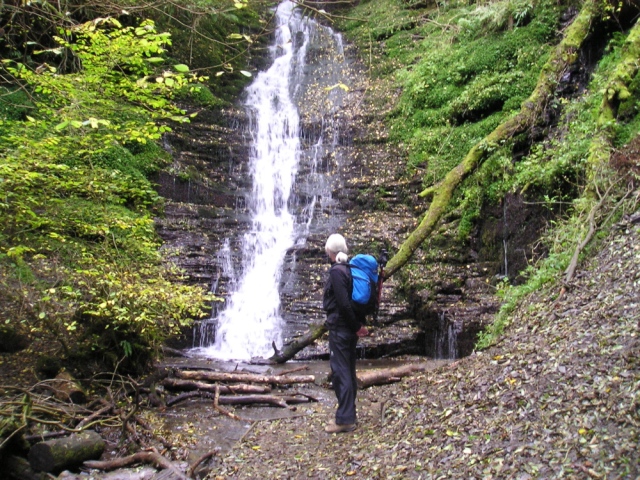
‘Water-break-its-neck’ waterfall in summer
After a month of not getting out on the hills and mountains, something had to be done! A trip down to friends in Mid-Wales opened up the chance of a hill day, and ambitious plans were made involving either the Elan Valley or Brecon Beacons – however, the weather forecast for the weekend came as something of a reality check, with winds of 40+ mph gusting past 60 mph. Back to the drawing board then!

The same waterfall in December 2015
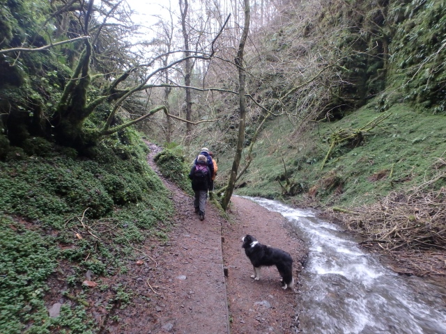
Making our way back from the falls ….

…. before heading up through Warren Wood
Back in 2010 we had done a short walk in Radnorshire (Powys) starting with a visit to the waterfall ‘Water break its neck’ – what a great name! The fall is spectacular in all conditions, but on this visit (December 2015) there was far more water than last time we were here. Still, we had come out for a walk, so it was a case of onward and upward. We left the swift flowing water and made our way up through Warren Wood to get out onto open ground.

Spooky looking sheep skull on the gate – “Go back, fools!”

Border Collie ‘Mist’ surveys the route ahead

The view down Llan-Even Dingle on a pleasant summers day ….
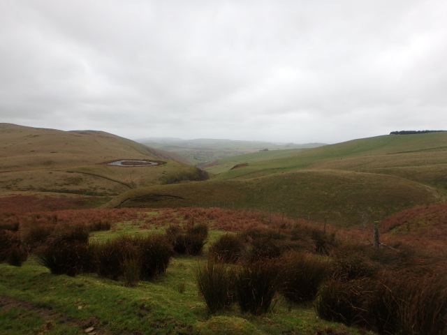
…. and the same view on a dank, blowy December day
Leaving the shelter of the wood it instantly became windier. A sheep skull on a metal gate looked like a tribal totem and an omen telling us to go back, but who believes that sort of thing? So, press-on we did. The area is mainly high moorland, with impressive deep-cut valleys known locally as ‘dingles’, but there was a sharp contrast between the views we had five years ago compared with this trip.

Heads down, and push on

In summer 2010 – near the high point of almost 600 metres

Time to head down
The higher we got, the less shelter there was from the wind, and to make progress it was a case of hoods up and heads down! The ground doesn’t feel particularly high, but a look at the map showed us to be at almost 600 metres altitude, the arbitrary height in the UK that determines if a hill is a mountain or not. Although the views suggested otherwise, the wind made it a wild mountain-like experience, and it was almost a relief to start to head down again.

Davy Morgan’s Dingle

The start of the descent path ….

…. with Davy Morgan’s Dingle now below

On the way home
The route back alongside Davy Morgan’s Dingle was almost all downhill, but we were now walking straight into that wind. Border Collie ‘Mist’ had the advantage of four-wheel drive compared with the humans, but we pressed on, finally getting some shelter from the wood as we got lower. If I make it sound like an ordeal it wasn’t really, in fact it was quite invigorating and helped blow away the cobwebs from the extra bottle of wine from the previous night! However, some people were having an ordeal, and not one of their choosing.
* * *

Mountain rescue teams in action in Carlisle – 5th December 2015
As we made our way back down, we were unaware of the drama being played out in Cumbria, after the passing of Storm Desmond. Carlisle, Appleby, Cockermouth and Glenridding were hit particularly hard by flooding, the third time in ten years in the case of Carlisle.
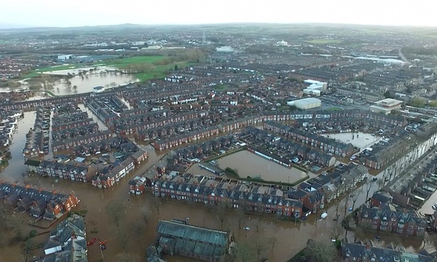
Carlisle flooded again – the third time in ten years
Volunteers from the RNLI, HM Coastguard and Mountain Rescue were deployed to assist. My own mountain rescue team NEWSAR (North East Wales Search And Rescue) sent ‘Swift-Water’ trained specialists to help alongside members of OVMRO (Ogwen Valley Mountain Rescue Organisation), our neighbouring team in North Wales. Also in action were rescue teams from the Lake District and Peak District, all working together to help out.
For the people of Carlisle it was a case of “Here we go again!”

Members of NEWSAR and OVMRO in action in the floods
Text and images © Paul Shorrock with the exception of the Carlisle images


I do need to get down to that area sometime, it looks rather nice.
LikeLike
It’s not spectacular Chrissie, but worth a look if passing through.
LikeLike
Don’t think I’ve ever done anything around there at all – it looks nice – especially Davy Morgan’s Dingle. Is there a Welsh name for the break-neck waterfall? I’ve never heard of it otherwise.
I class a mountain as being 2000 feet or over – haven’t heard anything in ‘metres’ for a mountain definition.
Carol.
LikeLike
Many of the names in this part of the world are English or anglicised Carol, which is no great surprise as the English border is only about 5 miles from the waterfall as the crow flies. There is a hill nearby named ‘Llan Evan Hill’ which is a mix of both languages with the Welsh Llan and English hill – also there is no ‘v’ in the Welsh alphabet, and to say ‘v’ you would use ‘f’. Nearby is another hill named ‘Nyth Grug’ (very Welsh!) which translates as ‘Heather Nest’ – I think I prefer the Welsh name.
Anyway, to get to the point and answer your question, I’ve never seen the waterfall ‘Water Break its Neck’ named in Welsh, perhaps because of the proximity of the English Border. There is a waterfall named ‘Hafren Torri Gwddf’ near Pumlumon, which translates as ‘Severn Break its Neck’, so I guess ‘Dwr Torri Gwddf’ must be close – any real welsh speakers able to help out?
Haha … you’re dead right, anything over 2000ft is regarded as a mountain in the UK, but I’ve been using metric in the hills for such a long time that I rarely use miles and feet, except on the road – when I’m driving I drive in miles! Interestingly though, the Nuttalls use 2000 ft as their base line as a mountain, then list the summits with heights in metres!
LikeLike
I can’t imagine using metric! and yeah, I knew about the Welsh alphabet and the F for V – I’ve been trying to learn the language since I was little. I had to give it up when I started French at school as it was too similar and haven’t managed to get back to learning it properly since unfortunately.
LikeLike
Going metric on maps makes sense – the contours and heights are already metric of course, and with the grid lines being 1km square it’s quite easy estimating distances on the map if you’re using kilometres.
All that’s left to do then is convert to a metric Naismiths Rule – I use 4kms per hour, which is (of course) 1km every 15 mins which is 1.5 mins for every 100 metres – makes time keeping on nav legs a doddle! 1 min for every 10 metres height gain works out at 10 mins for every 100 metres height – easy peasy!
LikeLike
Luckily for me, I’m good at converting metres back to my beloved feet and killermetres to my favourite miles. And I’m sure Naismith would have been imperial!
LikeLike
Great post Paul – and such a shame about our friends in Cumbria. I can’t believe how much they must have suffered, especially at Christmas. Lets hope the rain stops soon – I would happily swap it for snow 🙂 BTW, did you see the pics of the waterfall at Malham cove?
LikeLike
I’m also looking forward to some snow SP – the rain is getting beyond a joke!
The images of Malham with a waterfall were amazing – we’ll probably never see that again, though I should be careful what I say in case it should happen.
LikeLiked by 1 person
Another disaster for Cumbria is one disaster too many. We visited Glenridding this past summer.
LikeLike
Terrible news Andy – I’ve lived in or near all the places devastated by the flooding, including a two year spell living at Patterdale, just round the corner from Glenridding. I hope things get back to normal quickly.
LikeLike
It makes it so much more personal when you know a place really well, doesn’t it?
LikeLike
That looked like a great walk Paul. And yes the floods around Cumbria have been terrible, I have a friend in Appleby and they were some of the first houses to be inundated. She was flooded in 2009 too
LikeLike
It was a great walk for the conditions Mark – anything higher would have been a bit of a trial!
Poor old Appleby – I lived and worked in East Cumbria for many years, and they have had more of their share. The problem now seems to be that if the water does manage to get in over the higher flood defences it can’t escape, just prolonging the misery.
LikeLike